
FARMINGTON -- Farmington Planning Commission will have a public hearing on the city's proposed future land use plan at 6 p.m., Monday, Sept. 27, at City Hall.
The hearing is open to the public through Zoom. Citizens also will be allowed to attend in person, though there will be a limited number of people allowed in the room at a time because of covid-19 concerns, according to Melissa McCarville, city business manager.
Depending on how many show up, McCarville said people who want to comment on the plan may have to wait outside the room, come inside and speak and then leave afterward. Those on Zoom will be able to address the commission virtually.
McCarville said that unless an issue is raised during the public hearing, the planning commission most likely will vote that night on whether to forward the draft plan for adoption to the Farmington City Council.
This is the second public hearing on the draft plan. The first one was held in May.
After the first hearing, the commission decided to take its time to continue further discussions, said Robert Mann, chairman.
"We realized at that hearing that we weren't exactly 100% complete," Mann said last week. "The feedback we got made us realize that maybe we had missed something."
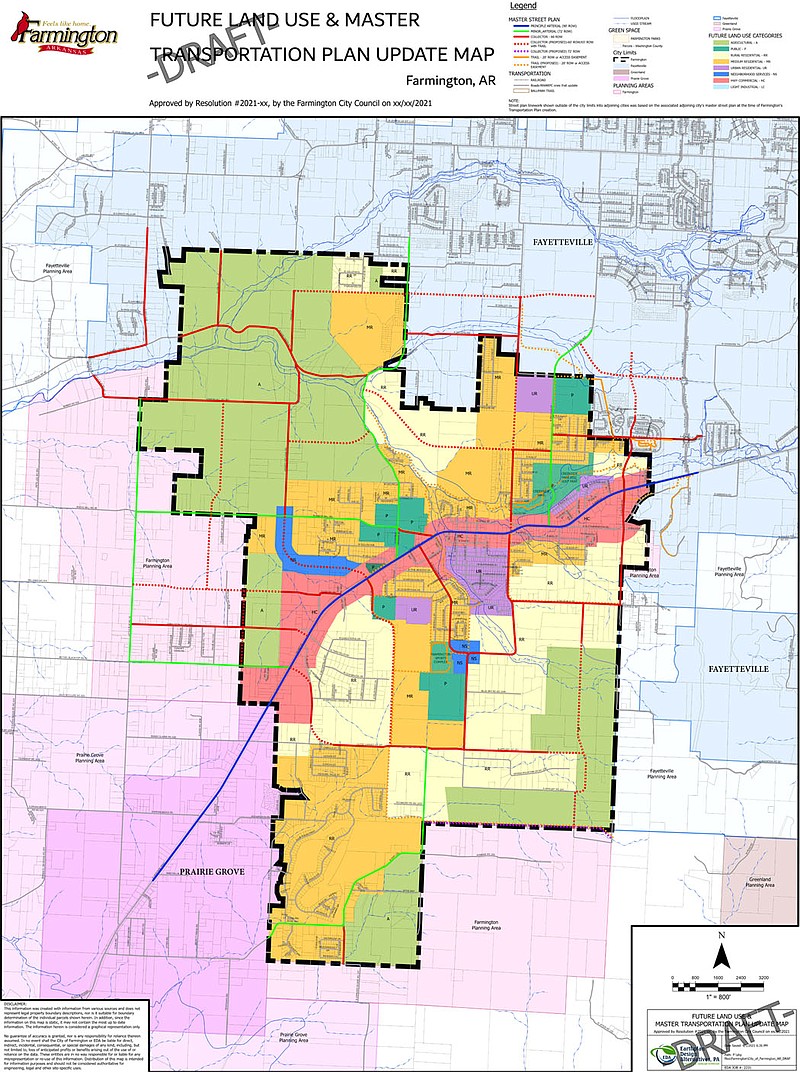
Mann said the future land use plan, which is different than the city's zoning designations, is fairly detailed and well thought out by the commission.
In creating the plan, with the assistance of Sarah Guertz, landscape architect with Earthplan Design Alternatives of Springdale, the commission looked at developments on the ground and where growth is expected to happen or could happen in the future, Mann said.
That's what drove the commission's discussions, Mann said, adding, "We made adjustments to the current trends and the kinds of developments that are going in."
Mann admits the process was exhausting with a lot of work and a "lot of gnashing of teeth." There were agreements and disagreements among commission members, he said.
"This commission is pretty broad in personalities and experience and opinions. I don't think there's a whole lot of stones that have not been turned over and looked at. I think they've done their due diligence."
Mann also believes the commission may have to reduce the time for when it reviews and updates the future land use plan the next time.
"Things have changed," Mann said. "Everything has changed. The whole landscape of the city has changed. We may have to take a look at it every two or three years. It's astounding how much growth has happened. Everything is exploding."
The draft plan has eight categories for land use in the city of Farmington and a definition for each use:
• Agricultural -- Areas used primarily for raising of crops or livestock. These areas also may include parks, recreation areas and environmentally sensitive lands. Density is one unit per two or more acres.
• Public -- Areas used for government buildings and services, such as schools, cultural facilities, cemeteries and parks. These generally are open to the public.
• Light Industrial -- Areas that provide suitable and appropriate locations for light industrial land uses allowed by municipal code. Principle uses include businesses such as warehouses, assembly and manufacture of prepared materials, packaging and wholesale businesses, or colleges and stadiums. It would have minimal effect on neighboring properties.
• Neighborhood Services -- Provides areas for commerce and provision of personal services for residents mainly within the city, instead of regionwide. A mix of residential and light non-residential uses is permitted in this category. Minimum lot size is 0.17 acres per residential unit and a maximum density of 5.81 units per acre.
• Urban Residential -- Areas of higher residential density, with densities that range from 5.81 units per acre up to 10.89 units per acre. Homes can be single-family residential or multi-family. Minimum lot sizes would range from .09 acre to .16 acre.
• Medium Residential -- Areas for single family residential detached homes on lots that range from 0.99 to 0.17 acre in size. Maximum densities would range from 4.36 to 5.81 units per acre. This category can have single-family homes and placement of businesses that would have a negligible impact on the surrounding single-family residential land uses.
• Rural Residential -- Areas for uses that range from agriculture to single family residential detached homes on land that is 1 acre and larger in size. Maximum density is one unit per acre.
Along with the document that names all eight categories is a map that shows where these land uses are presently being applied in the city or could be applied in the future.
A large copy of the future land use map can be seen at City Hall. Call 267-3865 to ask to see the map in person. The map also can be seen on the city website, cityoffarmingtonar.com, and on the city's Facebook page. The map is color-coded to show the different uses throughout the city.
Mann expressed his appreciation to Geurtz for her leadership with the project.
"She was a world of help," Mann said. "It was a good thing bringing her in. Sarah absolutely was amazing."